Monday, September 20, 2010
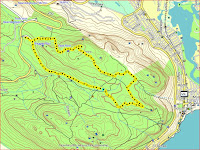
Route 2: Higher Steenberg Peak
From the Gate 2 Sign Post take the route that leads to Wolfkop. Follow the path past Wolfkop and up the climb to Steenberg Peak. Near the top of the climb there is a branch off to the right, keep left on the path. Carry on climbing until you get to a cairn at the "fat lady shelter" take a right and head back down the peak. You should soon be able to see the radio mast below and to the left. When the single track joins the jeep track turn left towards the radio mast. Follow the track all the way till you reach the top of Farmer Pecks. At this point you turn right back towards the car park. Keep on straight ignoring the first turn to the left, take the second left turn and run up the ridge towards St James Peak. There are one or two paths off to the right ignore them. You want to take the clear path to the right (the one at a right angle to the track that you are on). This path will take you up the hill towards Muizenberg cave. Just before the cave the path forks, take the left fork. Run on down to the jeep track. Turn Right and head for junction pool. Once you reach junction pool you turn right and then immediately left onto a single track. Follow this track until it reaches the Jeep track. Turn right - head on home.
Monday, September 13, 2010
Our esteemed leader : Peter Rogers
Helping out as group leader on the odd weekend:
Friday, September 10, 2010
Silvermine West - River Walk, Steenberg Ridge, Panarama loop
Start from the car park to the left of the entrance (Gate 1). Take the river walk to the mountain bike car park, through the car park. Left up the gravel road to the path on the right that leads up onto Steenberg Ridge. Follow that path northwards until it joins the Elephants Eye Path. Turn left onto the Elephants Eye Path (away from the look out) and head towards Houtbay lookout. At the junction with the main circuit path turn right for a shorter (10km) route back to the cars via the dam and the cycle route (runs next to the river walk) or turn right and do the Panarama loop before returning via the cycle route for just over 13km. If you fancy some more single track you can take the lower Panarama loop - about 12km.
Click to view a larger image:
Subscribe to:
Comments (Atom)


